

 64
64
 0
0
WEILA is introducing the WKG035BT0FY01, a multi-constellation, dual-frequency RTK GNSS module developed for embedded systems that require high-precision positioning.
Built around the ATGM332D-F8P core, the module combines multi-system GNSS reception, RTK correction support and standard positioning-data output in a 35 × 35 × 13 mm format.
WKG035BT0FY01 is designed for engineers integrating high-precision positioning into equipment rather than using a separate finished positioning terminal. Its RTK capability must be evaluated together with the correction source, host system, communication link, antenna installation and operating environment.
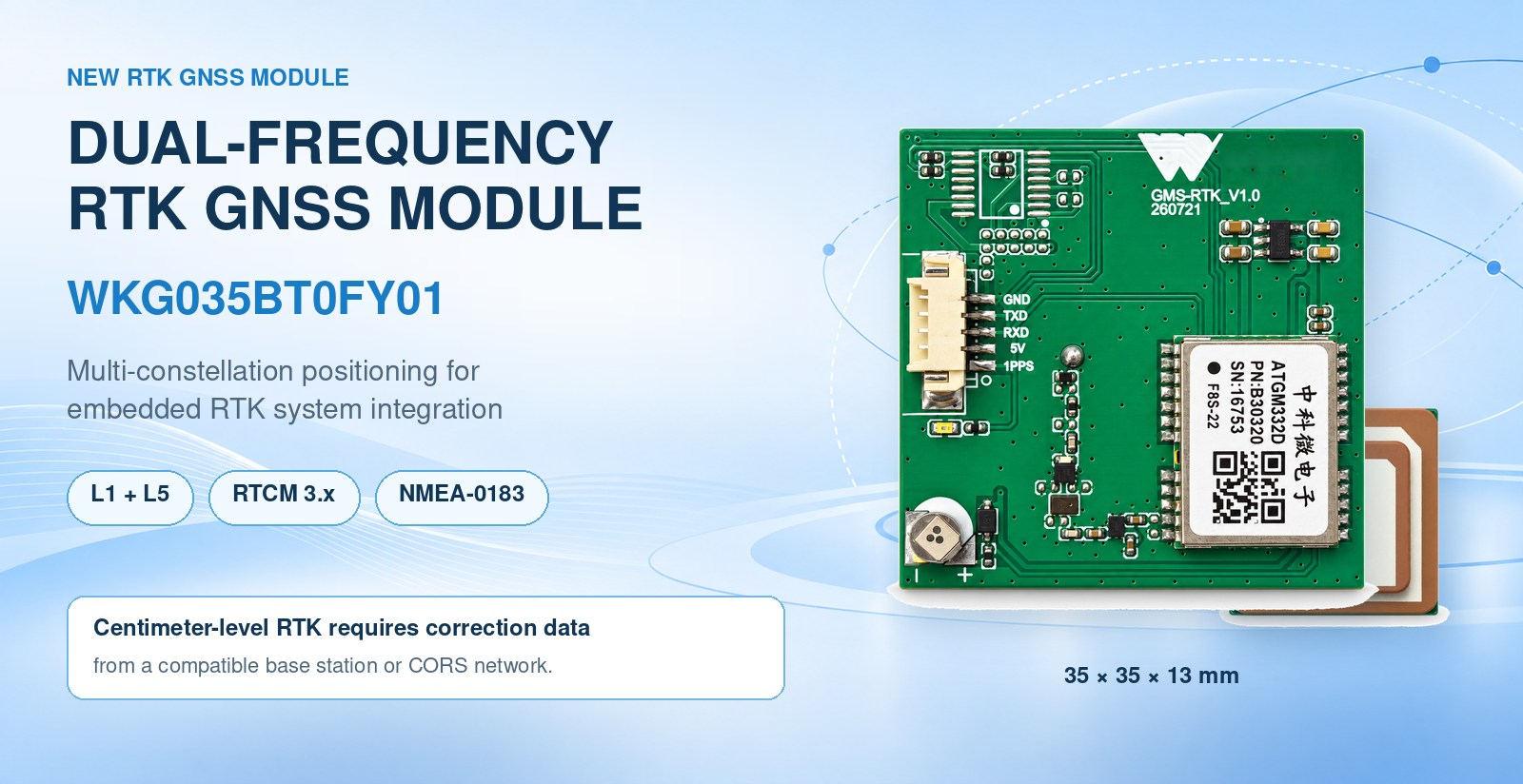
WKG035BT0FY01 supports signals from several global and regional satellite navigation systems:
- BDS: B1I, B1C and B2a
- GPS: L1 and L5
- QZSS: L1 and L5
- SBAS: L1 and L5
- Galileo: E1 and E5a
This multi-constellation, dual-frequency architecture gives system designers access to multiple GNSS signals within one module. The final constellation configuration and positioning strategy should be selected according to the target market, antenna system and application environment.
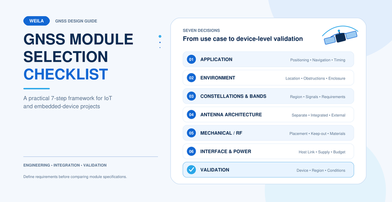
For teams still comparing positioning architectures, the WEILA GNSS Module Selection Checklist provides additional questions covering frequency bands, antennas, interfaces, power and system-level validation.
WKG035BT0FY01 supports dual-frequency RTK positioning. To achieve centimeter-level positioning, however, the module must operate with correction data supplied by a compatible base station or CORS network.
The complete RTK system therefore includes more than the rover module:
- The WKG035BT0FY01 installed in the target equipment
- A base station or access to a suitable CORS service
- A communication path for correction data
- Host hardware and software that manage positioning data
- An antenna installation suitable for the target environment
WKG035BT0FY01 supports RTCM 3.x, which should be considered when engineers define how correction data will be delivered within the finished system.
If correction data is unavailable or interrupted, the project should have a defined operating strategy. The required behavior will depend on the application and should be validated during system testing.
The module supports the NMEA-0183 protocol, with a default communication rate of 115200 bps.
During integration, the host system should be prepared to:
- Receive and process the required NMEA-0183 positioning data
- Manage the RTCM 3.x correction-data path
- Monitor the availability of the correction source
- Distinguish between normal GNSS positioning and the required RTK operating state
- Handle communication interruptions according to the product's safety and control requirements
The exact message configuration, physical interface, update requirements and host connection should be confirmed for each project.
For an overview of common receiver interfaces, see UART vs. RS-232 vs. USB for GNSS Receivers.
WKG035BT0FY01 measures 35 × 35 × 13 mm. This dimension should be evaluated together with mounting clearance, antenna orientation, enclosure materials and nearby electronic components.
Its confirmed power figures are:
- Continuous operating current: approximately 49 mA at 5 V
- Standby current: no more than 20 µA
These figures can be used as an initial reference for the module-level power budget. Total system consumption will also depend on the host processor, communication equipment, power conversion, antenna arrangement and other connected components.
GNSS performance is affected by the final installation. Engineers should validate antenna placement, grounding, enclosure effects and nearby interference sources in the complete product. WEILA’s GNSS Antenna Placement and PCB Layout Guide provides a useful starting checklist.
WKG035BT0FY01 can be evaluated for systems in which ordinary standalone GNSS positioning is not sufficient and RTK correction infrastructure is available. Potential areas include:
- Precision agriculture equipment
- Surveying and mapping instruments
- Robots, AGVs and AMRs
- UAV positioning systems
- Construction and industrial machinery
- High-precision vehicle equipment
- Smart logistics and port equipment
- Other high-precision embedded positioning systems
These are engineering evaluation areas, not claims of completed customer deployments. Actual performance must be verified in the finished product and its intended operating environment.
Before selecting WKG035BT0FY01, the engineering team should define:
- The target positioning requirement
- The base station or CORS source
- How RTCM 3.x data will reach the module
- The host interface and required NMEA-0183 data
- The expected correction-link availability
- The power and operating-mode requirements
- The available installation space
- The antenna position and surrounding materials
- The expected satellite-visibility and interference conditions
- The required behavior when RTK corrections are unavailable
Defining these conditions early helps determine whether the module, correction service and host architecture form a suitable complete system.
WKG035BT0FY01 combines dual-frequency, multi-constellation reception with RTCM 3.x and NMEA-0183 support in a 35 × 35 × 13 mm module.
Engineering teams evaluating the module can send WEILA their target application, positioning requirement, correction source, host interface, power conditions and installation constraints. WEILA can then review the module and integration requirements for the project.
Explore the WKG035BT0FY01 product page or contact WEILA for project-level discussion.
Yes. It supports BDS B1I/B1C/B2a, GPS and QZSS L1/L5, SBAS L1/L5, and Galileo E1/E5a.
No. Centimeter-level RTK positioning requires correction data from a compatible base station or CORS network. The correction link, antenna installation and complete system must also be properly integrated and tested.
WKG035BT0FY01 supports RTCM 3.x.
The module supports NMEA-0183, with a default communication rate of 115200 bps.
The confirmed module size is 35 × 35 × 13 mm.
Continuous operating current is approximately 49 mA at 5 V, while standby current is no more than 20 µA.
Not necessarily. Projects that only require standard positioning may not need RTK infrastructure. Selection should be based on the required accuracy, correction-data availability, power budget, mechanical design and total system cost.
Company Address
Floor 11, Block A, Building 9, Baoneng Science and Technology Park, Qingxiang Road, Longhua District, Shenzhen
Tel: +86 755-8329018
Business Hours
Monday–Friday
9:00 AM–6:00 PM (GMT+8)



+8613247518427



0755-8329018

13602688458

 Previous
 List
List